Showing posts with label sea. Show all posts

Tuesday, 16 March 2021

METHONI, GREECE

Methoni (Greek: Μεθώνη, Italian: Modone) is a village and a former municipality in Messenia, Peloponnese, Greece. Since the 2011 local government reform it is part of the municipality Pylos-Nestoras, of which it is a municipal unit. Its name may be derived from Mothona, a mythical rock. It is located 11 km south of Pylos and 11 km west of Foinikounta. The town is also known by the Italian name Modone, as it was called by the Venetians. Its economy is dominated by tourism, attracted by its beaches (including Tapia, Kokkinia and Kritika) and its historical castle.

Methoni has been identified as the city Pedasus, that Homer mentions under the name “ampeloessa” (of vine leaves), as the last of the seven “evnaiomena ptoliethra”, that Agamemnon offers Achilles in order to subdue his rage. Pausanias knew the city as Mothone, named after either the daughter of Oeneus or after the rock Mothon, which protects the harbour, and mentioned a temple to Athena Anemotis there. It was an important city in Ancient Greek, Roman and Byzantine times.

The Venetians had their eye on Methoni since the 12th century, due to its location on the route from Venice to the Eastern markets. In 1125, they launched an attack against pirates, who had captured some Venetian traders on their way home from the east, and who were inhabiting Methoni at that time. The Venetians took over the town in the aftermath of the Fourth Crusade, and secured recognition from the neighbouring Principality of Achaea through the Treaty of Sapienza (1209). A Roman Catholic bishop was installed in the local see.

The Venetians fortified Methoni, which developed into an important trade centre with great prosperity. Methoni became the important middle station between Venice and the Holy Lands, where every traveler stopped on their way to the East. A pilgrim who went by in 1484 admired its strong walls, the deep moats and the fortified towers. Nowadays the walls of the fortress, even though in ruins, continue to be impressive. The castle of Methoni occupies the whole area of the cape and the southwestern coast to the small islet that has also been fortified with an octagonal tower and is protected by the sea on its three sides. Its north part, the one that looks to land, is covered by a heavily fortified acropolis. A deep moat separates the castle from the land and communication was achieved by a wooden bridge. The Venetians built on the ancient battlements and added on and repaired it during both periods that they occupied the castle.

The castle of Methoni rises deserted and isolated today. When the winter winds hit its walls the locals say that you can hear the screams of the prisoners and the unjustly killed in the dungeons.

This post is part of the Our World Tuesday meme,
and also part of the Travel Tuesday meme,
and also part of the Wordless Wednesday meme.


Tuesday, 14 July 2020

CAPE COD, USA

Cape Cod is a geographic cape extending into the Atlantic Ocean from the southeastern corner of mainland Massachusetts, in the northeastern United States. Its historic, maritime character and ample beaches attract heavy tourism during the summer months. As defined by the Cape Cod Commission's enabling legislation, Cape Cod is conterminous with Barnstable County, Massachusetts. It extends from Provincetown in the northeast to Woods Hole in the southwest, and is bordered by Plymouth to the northwest.

Since 1914, Cape Cod has been separated from the mainland by the Cape Cod Canal. The canal cuts 28.2 km roughly across the base of the peninsula, though small portions of the Cape Cod towns of Bourne and Sandwich lie on the mainland side of the canal. Two highway bridges cross the Cape Cod Canal: The Sagamore Bridge and the Bourne Bridge. In addition, the Cape Cod Canal Railroad Bridge carries railway freight and limited passenger services onto the Cape. Cape territory is divided into 15 towns with many villages.

Provincetown (see below) is a New England town located at the extreme tip of Cape Cod in Barnstable County, Massachusetts, in the United States. A small coastal resort town with a year-round population of just under 3,000, Provincetown has a summer population of as high as 60,000. Often called "P-town" or "P'town", the town is known for its beaches, harbour, artists, tourist industry, and its status as a vacation destination for the LGBTQ community.

This post is part of the Our World Tuesday meme,
and also part of the Ruby Tuesday meme,
and also part of the Travel Tuesday meme,
and also part of the Wordless Wednesday meme.

Sunday, 12 July 2020

SFAKIÁ, GREECE

Sfakiá (Greek: Σφακιά) is a mountainous area in the southwestern part of the island of Crete, in the Chania regional unit. It is considered to be one of the few places in Greece that have never been fully occupied by foreign powers. With a 2011 census population of 1,889 inhabitants living on a land area of 467.589 km2, Sfakia is one of the largest and least densely populated municipalities on the island of Crete.

The etymology of its name is disputed. According to the prevailing theory, it relates to its rugged terrain, deriving from the ancient Greek word σφαξ, meaning land chasm or gorge. The crystal clear sea and warm climate, as well as the hospitable population, the traditional food and crafts, make it a wonderful tourist destination.

This post is part of the My Sunday Best meme,
and also part of the Photo Sunday meme.

Tuesday, 7 July 2020

KANGAROO ISLAND, AUSTRALIA

Kangaroo Island is Australia's third-largest island, after Tasmania and Melville Island. It lies in the state of South Australia 112 km southwest of Adelaide. Its closest point to the mainland is Snapper Point in Backstairs Passage which is 13.5 km from the Fleurieu Peninsula. Once occupied by Australian Aborigines, the native population disappeared from the archaeological record when the land became an island following rising sea levels several thousand years ago. It was subsequently settled intermittently by sealers and whalers in the early 19th century, and from 1836 on a permanent basis during the establishment of the colony of South Australia.

Since then the island's economy has been principally agricultural, with a southern rock lobster fishery and with tourism growing in importance. The largest town, and the administrative centre, is Kingscote. The island has several nature reserves to protect the remnants of its natural vegetation and native animals, with the largest and best-known being Flinders Chase National Park at the western end.

This post is part of the Our World Tuesday meme,
and also part of the Ruby Tuesday meme,
and also part of the Travel Tuesday meme,
and also part of the Wordless Wednesday meme.


Sunday, 5 July 2020

EUBOEA, GREECE

Euboea or Evia (Modern Greek: Εύβοια) is the second-largest Greek island in area and population, after Crete. The narrow Euripus Strait separates it from Boeotia in mainland Greece. In general outline it is a long and narrow, seahorse-shaped island; it is about 180 kilometres long, and varies in breadth from 50 kilometres to 6 kilometres. Its general direction is from northwest to southeast, and it is traversed throughout its length by a mountain range, which forms part of the chain that bounds Thessaly on the east, and is continued south of Euboea in the lofty islands of Andros, Tinos and Mykonos. It forms most of the regional unit of Euboea, which also includes Skyros and a small area of the Greek mainland.

This post is part of the My Sunday Best meme.

Sunday, 19 April 2020

BLUFF, NZ

Bluff is a town and seaport in the Southland region, on the southern coast of the South Island of New Zealand. It is the southern-most town in New Zealand (excluding Oban) and, despite Slope Point being further to the south, is colloquially used to refer to the southern extremity of the country (particularly in the phrase "from Cape Reinga to The Bluff"). According to the 2006 census, the usually resident population was 1,850, a decrease of 85 since 2001.

This post is part of the My Sunday Best meme.

Tuesday, 4 February 2020

SORRENTO, ITALY

Sorrento (Neapolitan: Surriento) is a small town in Campania, southern Italy, with some 16,500 inhabitants. It is a popular tourist destination which can be reached easily from Naples and Pompeii, as it lies at the south-eastern end of the Circumvesuviana rail line. The town overlooks the Bay of Naples as the key place of the Sorrentine Peninsula, and many viewpoints allow sight of Naples itself, Vesuvius and the Isle of Capri.

The Amalfi Drive (connecting Sorrento and Amalfi) is a narrow road that threads along the high cliffs above the Tyrrhenian Sea (we drove along there and it is not a drive for the faint-hearted!). Ferry boats and hydrofoils provide services to Naples, Amalfi, Positano, Capri and Ischia. Sorrento's sea cliffs and luxury hotels have attracted notable people, including Enrico Caruso and Luciano Pavarotti. Sorrento is famous for the production of limoncello, a digestive liqueur made from lemon rinds, alcohol, water and sugar. Other agricultural production includes citrus fruit, wine, nuts and olives. Wood craftsmanship is also well-developed.

This post is part of the Our World Tuesday meme,
and also part of the Travel Tuesday meme,
and also part of the Wordless Wednesday meme.

Tuesday, 26 November 2019

CAPRI, ITALY

Capri is an island located in the Tyrrhenian Sea off the Sorrentine Peninsula, on the south side of the Gulf of Naples in the Campania region of Italy. The main town Capri that is located on the island shares the name. It has been a resort since the time of the Roman Republic. Some of the main features of the island include the following: The Marina Piccola (the little harbour), the Belvedere of Tragara (a high panoramic promenade lined with villas), the limestone crags called sea stacks that project above the sea (the Faraglioni –see picture above), the town of Anacapri, the Blue Grotto (Grotta Azzurra), and the ruins of the Imperial Roman villas.

Capri is part of the region of Campania, Metropolitan City of Naples. The town of Capri is a comune and the island's main population centre. The island has two harbours, Marina Piccola and Marina Grande (the main port of the island). The separate comune of Anacapri is located high on the hills to the west. The island combines wild beauty, scenic views, cultural and archaeological treasures, cosmopolitan lifestyle, wonderful food and drink and hospitable people.

This post is part of the Our World Tuesday meme,
and also part of the Blue Monday meme,
and also part of the Travel Tuesday meme,
and also part of the Wordless Wednesday meme.

Monday, 11 November 2019

12 APOSTLES, AUSTRALIA

The Great Ocean Road is an Australian National Heritage listed 243-kilometre stretch of road along the south-eastern coast of Australia between the Victorian cities of Torquay and Warrnambool. The road was built by returned soldiers between 1919 and 1932, and is the world's largest war memorial; dedicated to casualties of World War I.

It is an important tourist attraction in the region, which winds through varying terrain alongside the coast, and provides access to several prominent landmarks; including the nationally significant Twelve Apostles rock formations. The Twelve Apostles is a collection of miocene limestone rock stacks jutting from the water in Port Campbell National Park, between Princetown and Peterborough on the Great Ocean Road.

This post is part of the Our World Tuesday meme,
and also part of the Travel Tuesday meme,
and also part of the Wordless Wednesday meme.

Tuesday, 29 October 2019

NIUE, OCEANIA

Niue (/ˈnjuːeɪ/ NEW-ay; Niuean: Niuē) is an island country in the South Pacific Ocean, 2,400 kilometres northeast of New Zealand, east of Tonga, south of Samoa, and west of the Cook Islands. Niue's land area is about 261 square kilometres and its population, predominantly Polynesian, was about 1,600 in 2016. The island is commonly referred to as "The Rock", which comes from the traditional name “Rock of Polynesia”.

Niue is one of the world’s largest coral islands. The terrain consists of steep limestone cliffs along the coast with a central plateau rising to about 60 metres above sea level. A coral reef surrounds the island, with the only major break in the reef being in the central western coast, close to Alofi. A notable feature are the many limestone caves near the coast.

Niue, whose capital is the village of Alofi, is a self-governing state in free association with New Zealand; and New Zealand conducts most diplomatic relations (though not all) on its behalf. Niueans are citizens of New Zealand, and Queen Elizabeth II is head of state in her capacity as Queen of New Zealand. Between 90–95% of Niuean people live in New Zealand, along with about 70% of the speakers of the Niuean language.

This post is part of the Our World Tuesday meme,
and also part of the Travel Tuesday meme,
and also part of the Wordless Wednesday meme.

Friday, 27 September 2019

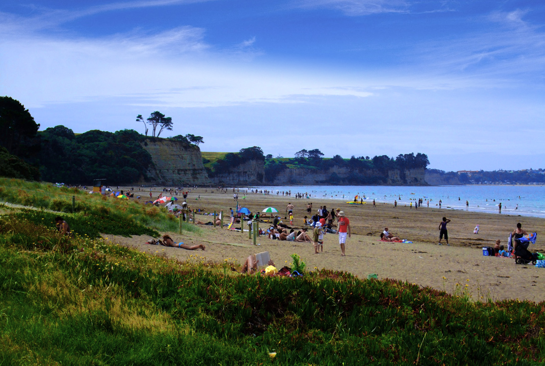
LONG BAY, NZ

Long Bay-Okura Marine Reserve protects a stretch of coastline on the east coast just north of Auckland city in New Zealand. The shores and waters of the reserve include a diversity of coastal habitats – the sandy beaches of Long Bay and Karepiro Bay; the rocky reefs off the two headlands at either end of Long Bay; and the sandflats and mudflats of the Okura River and estuary. Excellent public access and car parking facilities are found at adjacent Long Bay Regional Park, one of Auckland’s most popular weekend destinations.

Visitors to the marine reserve are welcome and activities like swimming, snorkelling, scuba diving, boating, photography and picnicking are encouraged. A walking track from Long Bay Regional Park extends northwards along the coast to the Okura River. A second walkway extends along the coast from Long Bay to Toroa Point.

This post is part of the Skywatch Friday meme.

Wednesday, 11 September 2019

JELLYFISH

Jellyfish and sea jellies are the informal common names given to the medusa-phase of certain gelatinous members of the subphylum Medusozoa, a major part of the phylum Cnidaria. Jellyfish are mainly free-swimming marine animals with umbrella-shaped bells and trailing tentacles, although a few are not mobile, being anchored to the seabed by stalks. The bell can pulsate to provide propulsion and highly efficient locomotion. The tentacles are armed with stinging cells and may be used to capture prey and defend against predators. Jellyfish have a complex life cycle; the medusa is normally the sexual phase, the planula larva can disperse widely and is followed by a sedentary polyp phase.

This post is part of the Wordless Wednesday meme,
and also part of the ABC Wednesday meme,
and also part of the Nature Notes meme.

Monday, 11 February 2019

ANDROS, GREECE

Andros (Greek: Άνδρος, pronounced [ˈanðros]) is the northernmost island of the Greek Cyclades archipelago, about 10 km southeast of Euboea, and about 3 km north of Tinos. It is nearly 40 km long, and its greatest breadth is 16 km. It is for the most part mountainous, with many fruitful and well-watered valleys. The municipality, which includes the island Andros and several small, uninhabited islands, has an area of 380 km2. The largest towns are Andros (town), Gavrio, Batsi, and Ormos Korthiou. The island is famous for its Sariza spring at Apoikia, where the water flows from a sculpted stone lion's head. Palaeopolis, the ancient capital, was built into a steep hillside, and the breakwater of its harbour can still be seen underwater. Andros also offers great hiking options.

This post is part of the Our World Tuesday meme,
and also part of the Blue Monday meme,
and also part of the Travel Tuesday meme,
and also part of the Wordless Wednesday meme.


Wednesday, 16 January 2019

BAYSIDE, MELBOURNE

The City of Bayside is a Local Government Area in Melbourne. It is located in the southern suburbs, with an area of 36 square kilometres and an estimated population of about 100,000 people. It comprises the City of Brighton, City of Sandringham, City of Moorabbin, City of Mordialloc and City of Bayside. As well as having quite exclusive and very expensive real estate by the seaside in Brighton, for example, it also has areas of industrial and business park usage, as in Moorabbin.

Lately we have had hot Summer weather and we went for a drive down the coastal road, visiting Elwood, Brighton, Hampton and Sandringham. The sea was perfect and there were many bathers, sail boat and motor boat enthusiasts, as well as the jet ski devotees. Many lovely beaches exist along this stretch of Melbourne's suburban coast, so it is a popular are for fun in the sea and sun. Add to that large numbers of great cafés, restaurants and all sorts of other eateries and you have the recipe for a perfect weekend outing.

This post is part of the Wordless Wednesday meme,
and also part of the ABC Wednesday meme.


Wednesday, 26 December 2018

YACHT

A yacht is a watercraft used for pleasure or sports. The term originates from the Dutch word jacht "hunt", and was originally defined as a light fast sailing vessel used by the Dutch navy to pursue pirates and other transgressors around and into the shallow waters of the Low Countries. The jacht was popularised by Charles II of England as a pleasure or recreation vessel following his restoration in 1660.

Today's yachts differ from other vessels by their leisure purpose. A yacht is any sail or power vessel used for pleasure, cruising or racing. A yacht does not have to have luxury accommodations to be a yacht, in fact many racing yachts are stripped out vessels with the minimum of accommodations. The term 'sailboat' is sometimes used in America to differentiate sail from powerboat.

The Sydney to Hobart Yacht Race is an annual event hosted by the Cruising Yacht Club of Australia, starting in Sydney, New South Wales on Boxing Day and finishing in Hobart, Tasmania. The race distance is approximately 630 nautical miles (1,170 km). The race is run in conjunction with the Royal Yacht Club of Tasmania, and is widely considered to be one of the most difficult yacht races in the world.

This post is part of the Wordless Wednesday meme,
and also part of the ABC Wednesday meme.


Tuesday, 18 December 2018

NEWCASTLE, AUSTRALIA

The Newcastle metropolitan area is the second most populated area in the Australian state of New South Wales and includes most of the Newcastle and Lake Macquarie local government areas. It is the hub of the Greater Newcastle area which includes most parts of the local government areas of City of Newcastle, City of Lake Macquarie, City of Cessnock, City of Maitland and Port Stephens Council.

162 kilometres NNE of Sydney, at the mouth of the Hunter River, Newcastle is the predominant city within the Hunter Region. Famous for its coal, Newcastle is the largest coal exporting harbour in the world, exporting over 97 megatons of coal in 2009–10 with expansion of annual capacity to 180 megatons in 2013. Newcastle exported 160 megatonnes of coal in 2017. Beyond the city, the Hunter Region possesses large coal deposits. Geologically, the area is located in the central-eastern part of the Sydney basin. Newcastle is on the southern bank of the Hunter River mouth.

The northern side is dominated by sand dunes, swamps and multiple river channels. A 'green belt' protecting plant and wildlife flanks the city from the west (Watagan mountains) around to the north where it meets the coast just north of Stockton. Urban development is mainly restricted to the hilly southern bank.

This post is part of the Our World Tuesday meme,
and also part of the Travel Tuesday meme,
and also part of the Wordless Wednesday meme.


Sunday, 18 November 2018

BEACH

Altona is a western suburb of Melbourne, Victoria, Australia, 13 km south-west of Melbourne's central business district. Its local government area is the City of Hobsons Bay. At the 2011 Census, Altona had a population of 9,918. Altona is a large suburb consisting of low density residential in the south-eastern half, with mixed industry in the north-western half. A key feature is Altona Beach on Port Phillip, which is one of only two swimming beaches in the western suburbs (the other being Williamstown Beach). Altona takes its name from the then independent German city of Altona which is today a borough of Hamburg.

This post is part of the My Sunday Best meme,
and also part of the My Sunday Photo meme,
and also part of the Photo Sunday meme.


Tuesday, 11 September 2018

OTHONOI, GREECE

Othonoi (Greek: Οθωνοί, Italian: Fanò) is an island and a former community of the Ionian Islands, Greece. Since the 2011 local government reform it is part of the municipality of Corfu, of which it is a municipal unit. It is the westernmost point of Greece, located northwest of Corfu. Population 392 (2011). It is the biggest of the Diapontia Islands. In the 19th century the island used to be the capital of the Diapontia Islands municipality, which also included nearby islands of Ereikoussa, Mathraki islets and rocks of Diakopo, Diaplo, Karavi, Kastrino, Leipso, Ostrako, Plaka, Plateia and Tracheia. Othoni is about 47 nautical miles from Santa Maria di Leuca cape, Italy.

According to a legend, in the ancient times it was the island of nymph Calypso who lived in a large cave. Odysseus fell in love and remained like a prisoner there for seven years. Homer called thιs island Ogygia. In the Odyssey one reads that there was a strong scent of cypress on this island. Othonoi is a place with many of these trees and on a hot day one may smell their resin. Odysseus left Ogygia by raft, which sank at Scheria on the island of Corfu. This is an extra element that justifies the legend of Othonoi being Ogygia, because of the short distance that separates the two islands.

Most beaches on the island are accessible by boat, including Ammos, Molos, Kamini, Kanoula, Kontoskes, Rogi, Fyki, Xilosermi, and Aspri Ammos (photo). It is a well known island for underwater photography because of the peculiar geomorphology of the seabed and the many caves. Othoni was frequently visited by the French naturalist Jacques Cousteau and his exploratory vessel Calypso.

This post is part of the Blue Monday meme,
and also part of the  Our World Tuesday meme,
and also part of the Travel Tuesday meme,
and also part of the Wordless Wednesday meme.

Tuesday, 19 June 2018

YALTA, CRIMEA

Yalta (Russian: Я́лта) is a resort city on the south coast of the Crimean Peninsula surrounded by the Black Sea. It serves as the administrative centre of Yalta Municipality, one of the regions within Crimea. Population: 76,746 (2014 Census). The city is located on the site of an ancient Greek colony, said to have been founded by the Greek conquerors who were looking for a safe shore (γιαλός – yalos in Greek) on which to land. It is situated on a deep bay facing south towards the Black Sea, surrounded by the mountain range Ai-Petri. It has a warm humid subtropical climate and surrounded by numerous vineyards and orchards. The term "Greater Yalta" is used to designate a part of the Crimean southern coast spanning from Foros in the west to Gurzuf in the east and including the city of Yalta and multiple adjacent urban settlements.

This post is part of the Our World Tuesday meme,
and also part of the Ruby Tuesday meme,
and also part of the Travel Tuesday meme,
and also part of the Wordless Wednesday meme.

Tuesday, 29 May 2018

PYLOS, GREECE

Pylos, historically known under its Italian name Navarino, is a town and a former municipality in Messenia, Peloponnese, Greece. Since the 2011 local government reform it is part of the municipality Pylos-Nestoras, of which it is the seat and a municipal unit. It is the main harbour on the Bay of Navarino. The town of Pylos has 2,561 inhabitants, the municipal unit of Pylos 5,402 (2001).

Mycenean Pylos is an important archaeological site located on the western coast of the Peloponnese in Greece. The Bronze Age site, located at modern Epano Englianos some 9 km north-east of the bay, was first excavated by Carl Blegen in 1952. Blegen dubbed the remains of a large Mycenean palace excavated there the Palace of Nestor, after the Homeric ruler Nestor, who ruled over "Sandy Pylos" in the Iliad. Linear B tablets recovered from the site by Blegen clearly demonstrate that the site was called Pylos by its Mycenean inhabitants. The site of Mycenean Pylos was abandoned sometime after the 8th century BC, and was apparently unknown in the Classical Period.

Old Pylos, the location of the town in Classical times, is to the north of the bay. The bay of Pylos was the site of two important naval battles: The Battle of Pylos, in 425 BC during the Peloponnesian War and the Battle of Navarino, in 1827 during the Greek War of Independence.

This post is part of the Blue Monday meme,
and also part of the Our World Tuesday meme,
and also part of the Ruby Tuesday meme,
and also part of the Travel Tuesday meme,
and also part of the Wordless Wednesday meme.